Project Lead: Anna Rallings
Project Type: MSc Integrated Studies in Land and Food Systems
Supervisors: Dr. Sean Smukler & Dr. Kent Mullinix
The Issue
The mosaics of ecosystem patches across a landscape contain within them a diversity of biological communities and ecological processes, such as nutrient or energy cycling. The ecosystems and their spatial relationship to one another – composition (the contents) and configuration (the layout) – have direct influence on the health of the broader ecology at a landscape scale.
Particularly in areas with extensive human land uses, patches of native vegetation in the landscape can provide critical sites for species and ecosystem services. These services result from the natural function of ecosystems and can provide valuable outcomes that human communities benefit from, including nutrient cycling, carbon storage or water retention. In areas of human land use, these patches are also important permanent and connective habitat for plants and wildlife. Biodiversity has become a major concern around the world and with increasing land use change, even habitats disturbed by human proximity –semi-natural –can support conservation efforts and climate change mitigation through the protection of carbon stocks.
As agricultural land uses have increasingly simplified their landscapes by removing semi-natural land cover and excluded non-production species through the use of physical or chemical impediments, making farms a barrier to native community dynamics (Vandermeer & Perfecto 2007, Balmford et al 2012). The Agricultural Land Reserve (ALR) in British Columbia was established in 1973 for the purpose of protecting the province’s key areas of food production. In the midst of urban growth in the south western part of the province, ALR parcels represent potentially valuable locations for connective and sheltering landscape patches of semi-natural perennial woody land cover composed primarily of shrubs and trees. However, the amount of semi-natural habitat (specifically woodlands and wetlands) has decreased 10.7% in Metro Vancouver and Fraser Valley between 2006 and 2011 (Agricultural Census of Canada, 2011). Although the specific fate of these patches is not known, these critical ecosystems and their related ecosystem services are likely lost to either expanding agricultural production or urbanization.
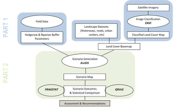
The Tools
On some agricultural lands, both historic and contemporary, non-production perennial woody vegetation is maintained by farmers’ management strategies. Two commonly used practices that enhance this vegetation are the planting and/or maintenance of hedgerows (linear perennial margins) and stream buffers (vegetated zones surrounding waterways). Organizations such as the Delta Farmland and Wildlife Trust (DFWT) in Delta, BC have implemented an incentive program for farmers to install/maintain features such as hedgerows and fallow fields. The Department of Oceans and Fisheries as well as the BC Ministry of Agriculture have guidelines for 15 meter stream buffer offsets from fish habitats to protect their quality. These policies mean to encourage the use of these strategies with the assumption that their implementation would have broad ranging benefits.
Previous studies have focused on assessing hedgerows and stream buffers at the farm level, providing an understanding of the localized effects. Hedgerows and stream buffer systems have the potential to increase the quantity and structural connectivity of perennial land cover across agricultural lands, however, the amount, type and distribution may have impacts on their outcomes as well as the amount of agricultural land needed to implement them.
Landscape ecology investigates the spatial relationships between landscape pattern and ecological process and has developed useful metrics for the evaluation of landscapes. Metrics of landscape pattern that have been shown to be highly correlated with terrestrial biodiversity and habitat quality (Uuemaa et al 2009, Walz 2011). In addition to assessing the identifying potential habitats, these kinds of remote monitoring techniques can be used for estimating the potential ecosystem services in a region by classifying land cover (Wilson 2010). Landscape ecology, landscape planning and ecosystem services studies have been refining the tools for assessment of landscapes for the past several decades and are now beginning to examine how site-scale management affects the landscape scale. Through the use of satellite imagery, land cover can be quantified, pattern can be analyzed and policy scenarios can be evaluated.
The Objective
This study will focus on building the framework for quantifying these non-production perennial landscape features, mapping land cover to assess the extent of these features and build scenarios to understand the potential influence these features may have on the region if implemented. The outcomes for each scenario include the quantity of non-production woody perennial land cover, its structural connectivity, the prospective carbon stocks as well as the change in agricultural land available for production.
The objective of this study is to investigate these outcomes for each policy scenario and evaluate their suitability and tradeoffs in the ALR of the Metro Vancouver and Fraser Valley Regional Districts in southwestern British Columbia.
References:
- Balmford, A., Green, R., & Phalan, B. (2012). What conservationists need to know about farming. Proceedings. Biological sciences / The Royal Society, 279(1739), 2714–24.
- BCMAFF, 2003. An Investigation of Existing Vegetative Buffers in BC and Their Effectiveness at Mitigating Conflict. Resource Management Branch, Abbotsford, BC. 93pp.
- Statistics Canada. 2011. Agricultural Census of Canada. [Accessed at http://www.statcan.gc.ca/ ca-ra2011].
- Uuemaa, E., Antrop, M., & Marja, R. (2009). Landscape Metrics and Indices : An Overview of Their Use in Landscape. Living Reviews in Landscape Research, 3, 1–28.
- Vandermeer, J., and Perfecto, I. (2007). The agricultural matrix and a future paradigm for conservation. Conservation biology : the journal of the Society for Conservation Biology, 21(1), 274–7.
- Walz, U. (2011). Landscape Structure , Landscape Metrics and Biodiversity. Living Reviews in Landscape Research, 5(3), 1–35.
- Wilson, S.J. (2010). Natural Capital in BC’s Lower Mainland: Valuing the Benefits from Nature. David Suzuki Foundation, ISBN 978-1-897375-34-1.